Showing posts with label Loop Head. Show all posts

Tuesday, 14 August 2018

Doondahlin …

Amongst the treasure trove of memorabilia belonging to our extended family is the following picture, painted on a thin sheet of masonite.  It is labelled “Doondahlin” and bears the artists initials of ‘A.E.’.  An identical picture hangs on the wall at a cousin’s beach house.  These pictures would have been a reminder of home to my Irish relatives.


Doondahlin, date unknown, by 'A.E.'
 from Pilkington Family Collection


Doondahlin was one of the homes associated with my family back in Ireland, and which in present times is a ruin.  I had no idea who ‘A.E.’ might be, as the initials did not relate to any known family. 

The painting  was brought to mind again a few months ago when I received an email from a man in Ireland, seeking information about Doondahlin for a local history group.  So back to the family archives I went, to see what I could find out.


Doondahlin was the summer home of the Keane family of Beechpark, in Ennis, county Clare, Ireland.  It was built for my 3x great-uncle, the infamous Marcus Keane, probably in 1854.  An entry in his sister Charlotte’s diary in October of that year reads:  “Marcus is building a fine lodge on the cliffs at Kilbaha”.  Kilbaha is a small village by the shore of the Shannon Estuary on the Loop Head Peninsula in Clare.  These West Clare lands were the ancestral home of the Keanes (formerly O’Cahane, or Ó Catháin in Irish), and previous generations of the family had been well-respected in the area.


Doondahlin, sketched by Sarah Haughton in 1859

from Pilkington Family Collection


Marcus inherited his father’s land agency business, raising himself up the social and financial ladder by marrying the daughter of a wealthy absentee landlord, and taking on the management of his father-in-law’s extensive estates.  He became notorious during an Gorta Mór (The Great Famine) for his ruthless evictions of poor tenant farmers and the destruction of their homes. 

Doondahlin took its name from an ancient Irish hill fort, the remains of which were located on the same cliff top.  Dun Dahlin was one of four hill forts along this stretch of Loop Head Peninsula, the origins of which are based in legend.


From:
Ring-Forts in the Barony of Moyarta, Co. Clare, and Their Legends
by Thomas Johnson Westropp

Part I.—From Loop Head to Carrigaholt
(Clare Library)

Marcus Keane considered himself something of a scholar on the subject of Irish antiquities, and wrote a book published in 1867 titled “The Towers and Temples of Ancient Ireland: their origin and history discussed from a new point of view”.  Perhaps it was this interest which led him to choose this site for his ‘fine lodge’.

In his book “The Houses of Clare”, Hugh Weir describes Doondahlin as a plain L-shaped, 2 storey house, with 3-bay front, and 4-bay wing along the east side, and a single-storey 3-bay wing on the west side.  According to this newspaper advertisement, there were 3 sitting rooms, 7 bedrooms and dressingrooms, 3 servants rooms, plus kitchen, pantries, and closets. I’ve also been told that the construction of the building included a layer of turf stacked between the double brick walls to act as insulation – probably necessary protection from the Atlantic gales blowing across that exposed cliff top.

Freemans Journal 2 June 1873
from Irish newspapers at findmypast.com

The house was used as a summer residence for Marcus, his wife Louisa and their children.  After Marcus’s death in 1883, Doondahlin passed to his son Marcus junior, who owned it until it was destroyed by fire in September 1921.  Marcus the younger’s daughter Helen has written some memories of her family’s life in Clare, and she writes of vividly remembering being at Beechpark one morning when a message was brought to say Doondahlin had been burnt the previous night.  This was during the War of Independence, during which the countryside was engulfed in trouble between the Republicans and the British troops including the dreaded Black and Tans. Doondahlin was targeted presumably in retribution for the actions of Marcus Keane during the previous century.
  
Marcus Keane filed a claim for compensation to the Irish Grants Committee in 1929.  I haven’t seen his claim myself, but I am told that it outlines a previous attempt at firing Doondahlin a few months earlier, which was thwarted by the attention of the caretaker.


So, back to the picture.  While searching for information to pass on to my Irish correspondent, I did a google search for “Doondahlin” and was surprised to find the following in an on-line art catalogue – a third copy of the very same picture, together with another of the view from Doondahlin across the Shannon to Mt. Brandon in Kerry.  Both pictures were surrounded by ‘folk art frames of oystershell’.  The pair of pictures had sold for $100 just a few months previously in October 2017.


The Australian Art Sales Digest, published by John Furphy Pty. Ltd., Melbourne, Australia.

According to the catalogue, the mystery ‘A.E.’ was an Irish/Australian artist by name of Annie Eldridge. Written on the rear of this picture was ‘Mrs. Eldridge, Rosehill, Buffalo Creek, South Gippsland’.   Buffalo is in the same district in South Gippsland where my family members from Ireland settled.


After some more investigation, I came up with two possibilities.  The first was Annie Eldridge nee Farrell, an Irish woman from county Galway, who was married to a William Eldridge. The couple ran a hotel in Wodonga for many years.  This one was promising, because a Farrell family were long-standing friends of my extended family in Gippsland, and the Eldridge family of Rosehill had a son named William.  It all seemed to fit perfectly – except that the Rosehill William Eldridge was married to someone else, and this Annie didn’t fit into the Farrell family we knew.  Additionally, I could not find anything linking this couple to South Gippsland.

The second possibility was Annie Eldridge the sister of William of Rosehill.  Although this Eldridge family were of English origins, not Irish, Annie married into a family with Irish connections.  She was born in 1866, making her a contemporary of my grandfather and his brothers, and she was definitely in the right location to be acquainted with my family.  I’m still unable to connect her to Doondahlin though, so not sure what opportunity she would have had to do the painting.  

All three pictures shown here - painting, sketch and photograph - are taken from a similar vantage point on the shore of Kilbaha Bay in front of what was Kiltrellig Lodge, home of my Pilkington family.  The Pilkington sisters who lived there took in paying guests to help make ends meet.  It is not unreasonable to imagine that IF Annie Eldridge had travelled to Ireland she may have sought accommodation with the family of her friends in Australia.


The ruins of Doondahlin, 2007
© K. Vincent 2007


Saturday, 28 January 2017

A Tale of Two Fishes …


Walking along the beach has always been a favourite thing to do.  The sea in all its moods holds a fascination for me, whether it’s a wild southern gale in winter, or watching a spectacular sky in summer as the sun sets over the water in the west.  I love exploring the myriad objects cast up by the sea – shells, sea creatures, seaweed, weathered driftwood, as well as varied other objects resulting from nautical activity.

Back in December, a post on a cousins Facebook page Doonagatha caught my attention.  Doonagatha  (from the Irish "Dún an geata" (translation – " close the gate ") is the name of the property originally farmed by my great uncle Dan, who came out to Australia from Ireland in 1895.  The property is still farmed by his grandson & family today.  The Doonagatha page chronicles daily life on a working beef farm, and is a good read.

So, a typical day on the farm winds up with a run on the Waratah Bay beach for the dogs.  In this particular post, an out of the ordinary discovery is made during the daily walk, of a dead whale washed up on the shore.  I followed with interest over the next few days as attempts were made to identify the species.  Eventually, it was confirmed as a pygmy sperm whale, and the carcass removed by authorities.


doonagatha whale 2
©Doonagatha Facebook page 2016.
Used with permission
                                   

Reading about this unfortunate creature sent me back to the diary of my great uncle Fred, where in 1905 he records the discovery of another whale on a beach across the other side of the world in county Clare, Ireland.

On Thursday 25th May 1905 he writes:
Cycled up to Fodra to see a monster fish that was washed ashore last night, and stranded on the rocks.  Walked up again with the girls and Hay after dinner, bringing a tape with me.  It measures 31 feet with a girth of 16. Lacey, the light keeper, took a photo of it.
Saturday 27th May:
Went up to Fodra and took some further measurements of the fish.
Tuesday 30th May:
Amy & I cycled to Fodra to see the fish, but the tide was over it.  Rode up again in the evening & saw it.  Dr. Studdert & others up there.  He says it must be buried or it will spread sickness in the place.
Wednesday 31st May:
Wrote a small account to the Clare Journal re the fish washed ashore at Fodra.
whaling
From Pilkington family collection


Monday 5th June:
My account of the fish in Saturday’s “Record”.

Fish story
"The Saturday Record"  3rd June 1905.

                                       used with permission of Clare Local Studies Centre,
                                                              Ennis, co Clare, Ireland

UPDATE 14/6/2022:  Since publishing this blogpost, the animal washed up on the shore in Fodra in 1905 has been positively identified as a Basking Shark (Cetorhinus maximus). Thanks to Frances Bermingham in Ireland for providing this ID.

Thursday, 4 September 2014

Loop Head Peninsula

Tuesday 27th May:
Up early today, and off to Loop Head to meet up with Laura Foley of The Long Way Round Walking Company.  I had been in contact with Laura a couple of weeks previously regarding a guided walk to see some of the places mentioned in our family diaries and letters. So today was the day, and it dawned fine and sunny.

As I had arrived back in Kilrush quite late the previous evening, I had decided to call at the supermarket first thing today to pick up some lunch supplies.  Hadn't factored in the Irish "nothing open before 0930" though! I did have some dry crackers and fruit left, so wasn't going to starve even if it was uninteresting!
I met Laura and her sister at the Loop Head carpark.  After changing into hiking boots, we set off for a 15km Loop Head hike.

Our way took us along the Shannon coast of the Loop Head Peninsula, and thanks to the weather there were clear views across the Shannon estuary to the Kerry mountains.  The similarities with the view across Waratah Bay to Wilsons Promontory at home were obvious, and I'm sure that it would have been a constant reminder of their Irish homeland for my grandfather, his brothers and cousin.

Across the Shannon to Kerry


The first point of interest was the Hanging Gardens.  In the 19th century, Henry Keane, brother of the both the infamous Marcus and my 2x great grandmother Anne, had a summer residence known as The Cabin along the Loop Head Peninsula.  On the cliff face below his home, there is a wide ledge, its location providing shelter from the Atlantic weather.  Henry Keane widened an existing crevasse in the rocks to provide access to the ledge, and created a garden here.  Nothing remains of Henry's home or garden today, but the ledge is a picture of sea-pinks and provided us a sheltered grassy spot to admire the view and enjoy the scones provided by Laura.


Entrance to Hanging Gardens


The rock wall of the Hanging Gardens
 
We continued our walk along the Shannon coast, visiting places with names familiar to me from my great-uncle Fred's diaries in 1904-05, and earlier from his cousin Amy Griffin's diary of the 1870's.
Poulnapeasta - the water dragon's lair, Moab's Washpot, Aillnagroagh and Horse Island.  Laura was a wealth of information on the area, including the botany, pointing out various plants which were edible, and identifying the wildflowers.
Moab's Washpot

Horse Island
Horse Island is not actually an island at all.  Unfortunately, it has been fenced by the current owner, so it wasn't possible to go onto it.


Aillnagroagh as sketched by Sarah Haughton in about 1859

Aillnagroagh as photographed by me in May 2014


Not a lot has changed in the past 150 years!  Minus one stack, but otherwise pretty much as it was.
 
From Horse Island, we left the coast and cut across farmland to the Atlantic side of the peninsula, coming out near Fodry, and following the cliffs back to the lighthouse. The scenery on this side was every bit as spectacular as along the Shannon.
 
The beautiful sea-pinks

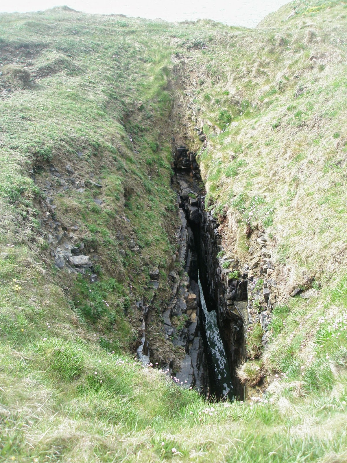
The Chimney is a rock formation mentioned in Amy's diary.  Passing through the Chimney seems to have been a challenge to be passed by all family and visitors to the Kilbaha cottage.  I was keen to see this formation, and Laura pointed it out with the advice that it wasn't something she would recommend doing.  It was quite a deep hole in the rocks leading down to the shingles below, and the potential for accidents would be significant.  I don't know how much it may have changed since Amy's days, but my impression from her writings is that it was quite a narrow opening.

The Chimney
Further round we came to Gull Island, so named for the masses of gulls nesting on the rock ledges along the sides.  With this came spectacular views back to the lighthouse and Lovers Leap - the gap between the mainland and Diarmuid & Grainne's Rock, also known as Cuchullins Leap.  This was the location of Amy Griffin's daring crossing in a makeshift crane which hoisted her across.
Gull Island

Lighthouse & Lovers Leap
The birdlife along the cliffs on the way back was amazing. Apart from the gulls, there was a large colony of Guillemots nesting. These birds only spend time on land while nesting, coming ashore in May and leaving their nests again in August.
 
It was a great walk on a beautiful spring day, tracing the footsteps of my forebears, in the places they loved and wrote about.  Thanks to Laura for helping me to add another layer of memories to those passed down the generations.

Guillemot egg


unknown wildflower

Saturday, 9 August 2014

County Clare - Day 1: Ennis & Carrigaholt

Monday 5th May
Why is it that you would never in a million years consider drinking Guinness at home in Australia (because it tastes like ****), yet in Ireland you not only drink it and think nothing of it, but actually enjoy it too?  Anyway, it was to be a fitting end to an amazing first day.

The Rowan Tree Hostel, seemingly growing out of the River Fergus, is an elegant building which was in a former life the Ennis Club.  In the 19th century, the predominantly Protestant landed gentry and professional men of the county, including my ancestors, would have met here to enjoy a drink and a smoke, to discuss matters of import and the state of the county.  Perhaps the 19th century equivalent of the 21st century Mens Shed movement?

Rowan Tree Hostel
In its current life it is a comfortable hostel providing centrally located accommodation to visitors from far and wide, and is my base for the first stage of my Irish adventure.

So, it's from here that I set off on my first morning, headed for Carrigaholt, on the Loop Head Peninsula, by the Shannon River.  My purpose is to take part in the Famine Walk, commemorating the lives of the 41West Clare people who drowned in the Cammoge ferry disaster in December 1849.
The people were famine victims, starving and desperate, and had walked miles from their homes to catch the ferry across Poulnasherry Bay to Kilrush where they sought assistance at the Workhouse.  Unfortunately, they were turned away and with no alternative they were forced to return to their homelands.  Catching the last ferry of the day, they set out on the return journey, but misfortune struck only metres from the opposite shore, when the overcrowded and unseaworthy ferry capsized and sank.  In their poorly clad and emaciated state, they were no match for the harsh winter conditions, and if they didn't immediately drown they would have rapidly succumbed to hypothermia.

The Famine Walk began last year as part of the activities planned when Kilrush hosted the 2013 National Famine Commemoration.  The walk followed in the footsteps of those lost, and a memorial was erected on the shore at Cammoge.  It is anticipated that the walk will become an annual event as part of the Loop Head Walking Festival which takes place over the May Bank Holiday weekend.

We set off from Carrigholt as a group of 12 or so, under the guidance of Michael O'Connell, a fountain of knowledge on the Cammoge incident and on all things local - both historical and contemporary. After completing 11 or 12 kilometres, passing through locations with names familiar to me from family tales, we were compelled to abandon the walk just a kilometre or so  from the endpoint, when we were caught in an absolute deluge of rain.  Help was called for and very soon 3 cars arrived to carry us back to Carrigaholt where we retired to the Long Dock restaurant and warmed up with some delicious food and good company.


Wonderful to meet up with Paddy Waldron too, after an email correspondence of a couple of years.  Paddy is, I am convinced, related or connected to every single person in or from Ireland!

And so, back to Ennis, to meet up with Larry Brennan with whom I collaborated on the Waterpark booklet project, and an enjoyable hour or so spent with him over the afore-mentioned pint.